


|
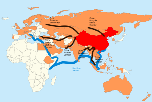
Mapping the Belt and Road Initiative
|
|
| Author: | Sarah Bremer |
| Essential Question: | How does transportation infrastructure promote economic development and trade? |
| Summary: | This lesson explores China’s Belt and Road Initiative through a spatial perspective. Through this lesson, students will apply skills in online research, written synthesis of ideas, and spatial reasoning to develop a collaborative online map. They will also analyze the importance of factors such as natural resources, relative location, transportation infrastructure, and tourism in relation to economic development. |
| Grade Level: | 10-12th grades |
| Subject Areas: | AP Human Geography (10-12th grade), economics, foreign policy, or AP Comparative Government |
| Keywords: | Belt and Road, Infrastructure, Geography, Economic Development |
| Lesson Duration | 2 80-minute block periods |
| Published | July, 2018 |
| Source | 1990 Institute Curriculum Development submission |
Lesson Plan (PDF):
Sarah-Bremer-Mapping-the-Belt-and-Road-Initiative.pdf
Supporting Documents:
- 2000px-One-belt-one-road.svg_.png
- Sarah-Bremer-Handout-One_-Mapping-the-Belt-and-Road-Initiative.pdf
- Sarah-Bremer-Handout-Two_-Mapping-the-Belt-and-Road-Initiative.pdf
- Sarah-Bremer-Handout-Three_Mapping-the-Belt-and-Road-Initiative.pdf
One Response to “Mapping the Belt and Road Initiative”
courtneycaldwell
This lesson is great! I have modified it to work in my classroom and the kids are really enjoying it! Thank you for sharing!